
- Projects & Programs
- Durham-Scarborough BRT
- Get Involved
- Whitby Community Open House - May 2021
UNPUBLISHED Durham-Scarborough BRT Whitby Community Open House - May 2021
Archive – May 20, 2021
On May 20th, 2021 Metrolinx and the DSBRT Project Team hosted a virtual open house for the Whitby community to overview the refined 3-Lane preliminary design option.
Thanks to the community engagement thus far, the design has evolved from curbside dedicated transit lanes, to a full pedestrian transit mall, to a north side pedestrian mall, and now to a three-lane design with a westbound mixed traffic lane.
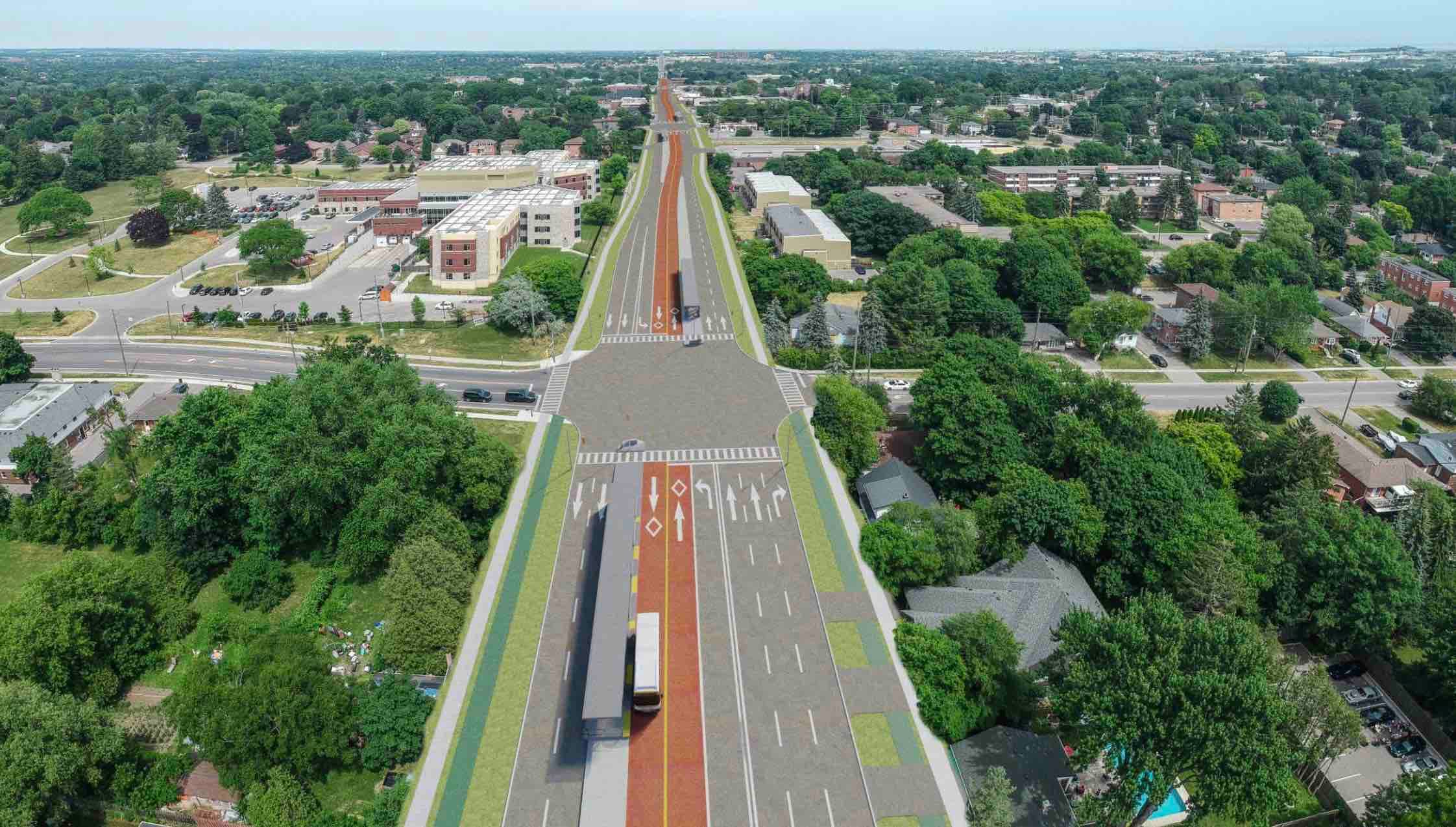
The refined preliminary design includes three lanes of traffic, which will provide eastbound cars and buses with a dedicated lane, and westbound cars and buses with a shared lane between Perry Street and Byron Street.
This new option will:
- Maintain continuous eastbound and westbound general traffic movement on Dundas Street
- Minimize neighbourhood traffic infiltration and keep school buses, trucks, large vehicles on Dundas Street
- Improve pedestrian, transit, and driving access to businesses and support step free access on both sides of Dundas Street
- Provide more space for streetscaping and enhance the public realm on Dundas Street
- Maintain the character of Downtown Whitby
- Restore all 31 on street parking spaces, through an expanded parking lot at Elm Street and Byron Street
Metrolinx will continue to consult with the community, stakeholders, elected officials and municipal and regional partners to fine tune the three-lane preliminary design option.
To keep informed on upcoming public engagements, please subscribe to the Metrolinx Durham regional e-newsletter, and to the project mailing list by e-mailing the team at DSBRT@metrolinx.com. For more information on the DSBRT project and previous public engagements, please visit Metrolinx Engage.
Presentation Materials
Virtual Open House – May 20, 2021 Outstanding Questions
⌄ 4 Lane Option
Between Brock Street and Bryon Street, the three-lane design provides one westbound lane for all vehicles, including a mix of cars, trucks and buses; one eastbound transit-only lane; and one eastbound lane for general traffic. West of Byron Street and east of Brock Street, the proposed design is four-lanes, with two centre-median transit-only lanes and two general traffic lanes (one in each direction).
Over the last few years, our technical experts have explored a variety of options for downtown Whitby. Based on the feedback received through several rounds of public engagements, the preliminary design has evolved from curbside dedicated transit lanes, to a full pedestrian transit mall, to a north side pedestrian mall, and now the technically preferred three-Lane mixed traffic westbound design.
This design:
- Maintains continuous eastbound and westbound general traffic lanes on Dundas Street
- Minimizes neighbourhood infiltration and keeps school buses, trucks, and other large vehicles on Dundas Street
- Improves pedestrian, transit, and driving access to businesses
- Supports step-free access to businesses along Dundas Street which currently require at least one step to their doors
- Provides more space for streetscaping and enhances the public realm on the north side of Dundas Street
- Maintains the character of Downtown Whitby
- Relocates all 31 on-street parking spaces through an expanded parking lot at Elm and Byron Streets.
Metrolinx will continue to consult with the community, stakeholders, elected officials and municipal and regional partners to fine tune the three-lane preliminary design option. The latest refinements reflect the valuable feedback we’ve received through our public and stakeholder engagements.
⌄ Stop Locations
The proposed location of the westbound bus stop, west of Brock Street, provides the most reliable and efficient transit operation. Buses will experience less delay with the stop after the Brock Street signal. Buses will be able to continue on their route after serving passengers at the bus stop, without the risk of having to wait at a red light. The traffic signal priority will also perform better if it needs to get the bus through the intersection without having to account for variable times serving the stop. As the number of passengers using the stop at any time can vary quite significantly, it is challenging to determine how long to hold the westbound green light for the bus.
If the bus stop is moved east of Brock Street, it will limit the number of westbound cars that can turn right from Dundas Street to go north on Brock Street, potentially increasing the number of cars that will need to use Perry, Ash or Hickory to turn north off Dundas, infiltrating into the local neighbourhood.
The location of the westbound bus stop will be reviewed and can be refined in detail design.
Optimizing this stop location might include moving the platform closer to Byron Street, or to the east side of Brock Street.
⌄ Traffic Infiltration and Congestion
We understand that traffic infiltration is a major concern. The refined three-lane design from Brock Street to Byron Street provides an eastbound general traffic lane and a westbound mixed traffic lane, minimizing neighbourhood traffic infiltration compared to the previous design concepts. The added volumes predicted with the 3-Lane option are similar to the levels of traffic increase that would be seen without the DSBRT.
The dedicated transit lanes will require some local changes in traffic and travel patterns. The project team have been analysing traffic in detail to understand the potential for local road infiltration in Downtown Whitby. The analysis indicates that approximately 20% of the traffic on Dundas Street today is long distance trips, that do not begin or end their trip in Whitby.These trips are likely to divert onto major arterial roads such as Rossland, Taunton or Highway 401.
More than one third of the traffic begins or ends their trip in the downtown area, meaning that they are already using local streets for much of their trip.
The balance of the traffic are medium length trips that are within the Town of Whitby.
We understand that motorists may choose to drive along other local roads, depending on their destination.
Metrolinx is committed to working the Town of Whitby throughout detail design to identify any future requirements for the project.
⌄ Public and Stakeholder Consultation and Engagement
We’re working hard to deliver this important project and we will continue to analyze refinements to the preliminary design, in order to respond to the recent feedback we have received from the community and from various stakeholders, elected officials and our municipal and regional partners.
We heard from Whitby Council, residents and stakeholders that additional consultation was needed. In the last 6 months, the Metrolinx project team has reached out to:
- 4 Whitby Advisory Committees of Council
- Multiple meetings with the Whitby BIA, Chamber of Commerce, and Downtown Whitby Development Steering Committee
- Held numerous meetings with individual stakeholders, businesses, residents, Town councillors and MPP Coe.
- Presented at a special meeting of Town Council on April 22
- Mailed out just under 50,000 informational tent cards to the entire municipality
- Created two blog stories focused on the Whitby community on Metrolinx news
- Had two promotional street signs erected leading up to the May 20 virtual open house
- Hosted 3 public meetings: January 7, March 16 and May 20. All of the material from these meetings, including answers to questions are available on the project website under “Past Events”.
As noted on slide 7 of the May 20 meeting material, MPP Lorne Coe has been briefed on the plan’s status and consultations to date. His primary concerns are the impact on area residents and businesses, and he has encouraged broad and deep consultation with the community and Whitby Council towards a satisfactory outcome.
If you have any comments you would like to share with the project team, please use the contact us form or e-mail us at DSBRT@metrolinx.com.
To stay informed on upcoming public engagements, please subscribe to our project mailing list and Durham regional e-newsletter by e-mailing us at DSBRT@metrolinx.com.
⌄ Project Purpose and Need
Over the last several months, public health restrictions in response to COVID-19 have had a large impact on travel patterns. While there is uncertainty surrounding the “new normal”, we know that the use of private cars for all trips is not sustainable or viable. Transit ridership patterns go up and down but over time, the long-term trend is continuing up. Durham Region is the fastest growing region in the Greater Toronto area and will continue to grow, and we need to find solutions to move more people more efficiently.
Transit remains an essential service and is required for those who do not have a vehicle or who cannot or choose not to drive. Metrolinx is investigating the potential long-term impacts of COVID-19 on transit ridership; however, it is too soon to apply this work to our projections, as there is currently insufficient data and information available. While the industry expects it will take a few years for transit ridership to recover to pre-pandemic levels, note that the Durham-Scarborough BRT is not expected to be delivered until the late 2020s.
While the impact of COVID-19 to ridership has been significant, routes such as the 900 PULSE have been impacted less than services to downtown Toronto. Healthcare workers, essential retail workers and manufacturing workers continue to use transit as part of their travel to and from work. As retail and educational travel restarts, we expect to see ridership rebound quickly on DRT routes.
When we look out to 2041, and beyond, the growth that is planned for the overall corridor and the potential for transit to provide a greater role in managing mobility in the corridor make a compelling argument for improved transit service and the need for dedicated lanes to provide the reliability needed to attract riders. Previous studies indicate that there is significant benefit to implementing transit priority in this corridor and that the costs are in keeping with the benefits. The Initial Business Case, completed in 2018, indicated a positive cost-benefit ratio, which means that economic benefits exceed the cost of implementing the project. Once the preferred design is selected the costs and benefits will be updated as part of the Preliminary Design Business Case which will be available in 2022.
Bus Rapid Transit (BRT) is the preferred technology for the Durham-Scarborough corridor. Light Rail Transit and Bus Rapid Transit were evaluated as part of the Initial Business Case.
LRT is a great solution for high-density urban areas. This is because of the high capacities it can accommodate. A 30 metre LRT vehicle can move 2500 people per hour in each direction, whereas an 18-meter articulated bus can move 900 people per hour in each direction. On the Durham-Scarborough BRT line, it is projected that roughly 750 people will be moving per hour in each direction through Whitby, thus well under the threshold of LRT capacity and more in line with a BRT solution.
LRT is much more expensive to implement due to the additional infrastructure requirements, such as the rail line, electric power supply, and additional costs associated with relocating utilities that run in the centre of the road underneath the tracks. Whereas with BRT, any utility relocation would be localized to facilitate road widening.
In addition to being a more cost-effective solution based on current and future ridership projections, BRT also provides more flexibility than a single route. Additional bus routes can use the same lanes for part of their trip – but serve other areas. For instance, a route could use the future Simcoe Street BRT in Oshawa, turn west along Highway 2 to service Oshawa and Whitby, and then get onto Highway 412 to head to York Region. Other routes could run along part of the corridor and then connect to GO stations or other major destinations off the corridor. This operational flexibility would allow more passengers to have a one-seat ride, saving them time and transfers.
⌄ Safety
At Metrolinx safety is our top priority. The design options developed for Whitby were designed with safety in mind. The three-lane option would improve safety for pedestrians on Dundas Street by upgrading the sidewalk and improving accessibility into the local businesses. Outside downtown Whitby, the project will also upgrade sidewalks and crosswalks on Dundas Street to be accessible, create raised and barrier protected platforms at stops for transit users, and for drivers by reducing road conflicts and concentrating left-turns and U-turns at protected, signalized intersections. Details for the design of the new sidewalks, such as lighting, benches, planters, bollards, or other infrastructure will be examined as the project moves forward.
The team are consulting with police, paramedic, and fire services to develop a design that does not impact delivery of critical emergency services. The transit lanes will be available for emergency service vehicles, providing them with a dedicated lane to move around traffic congestion.
DSBRT stops are located at signalized intersections, providing a protected crossing for pedestrians to access the platform. Recent experience along the VIVA Bus Rapid Transit network in York Region saw 51%-74% fewer collisions, likely due to eliminating midblock left turns across traffic (YRRTC Annual Report, 2019, http://www.vivanext.com/PDFs/Corp/YRRTC_Annual_Report_2019.pdf).
⌄ Planning and Studies
The project is currently in the preliminary design and environmental assessment stage. Completion of the project is a long-term goal that is dependent on detailed design, funding, additional technical studies, and future consultation.
The project considers current and future ridership levels. The Initial Business Case completed in 2018 demonstrated the economic benefits of investing in transit priority along this corridor. Ridership on the existing Durham Region Transit PULSE 900 route has exceeded initial projections by more than 50%. The service carried more than 3 million passengers in 2019. Running more frequent transit service in dedicated bus lanes is expected to double ridership levels. In Downtown Whitby, about 900 people got on and off the bus stops between Annes Street and Garden Street every day (pre-COVID, 2018). Through Downtown Whitby, about 5,400 people ride the bus every weekday.
Future ridership is determined based on forecasts of population and employment along the corridor, based on land use and provincial and regional growth policies. There are many areas along the corridor that are identified for high growth in the future, including Whitby, Downtown Oshawa, and Downtown Pickering.
Growth is planned across the Region, and while significant growth will occur in the northern sections of Whitby, growth will continue in proximity to Dundas Street.
Dundas Street was selected as the preferred route for a BRT system through the 2041 Regional Transportation Plan (2041). Other corridors, like Taunton Road have been selected for other transit projects, which will proceed through separate studies.
The project will follow the Transit Project Assessment Process (or TPAP), which requires that all environmental factors be reviewed, that impact assessments be undertaken, and mitigation and monitoring requirements be developed. Studies are nearing completion and will be circulated as part of the formal TPAP approval. The studies include:
- Air Quality,
- Archaeology,
- Cultural Heritage,
- Environmental Site Assessment (contamination),
- Natural Environment,
- Socio-economic and Land Use,
- Noise and Vibration,
- Traffic, and
- Tree Inventory
⌄ Parking, Pedestrian, Business and Accessibility Access
One of the goals of the project is to improve walkability along the corridor, including in Downtown Whitby. As part of the project, sidewalks will be widened to increase the size of the public realm. Currently, there is not enough space for stores to place accessible ramps (or “stop gaps”) outside their door. With the expanded public realm, new sidewalks will be constructed along Dundas Street. During the detailed design stage, Metrolinx will work with businesses to make front door stores more accessible, for example by raising the sidewalk to reduce or eliminate steps. During the detailed design stage, Metrolinx will also review opportunities to refine the design to widen the south sidewalks between Byron and Brock. The existing buildings between Bryon and Block are not impacted by the proposed design.
With larger sidewalks, businesses will also be able to place displays outside their stores to attract customers. The widened pedestrian realm will also provide more space for streetscaping, sidewalk sales, outdoor dining, and pedestrian amenities, which will help make it a destination and attract more people.
At Celebration Square in Whitby the project will have several impacts. There will be an important BRT stop to provide service to the west end of downtown and activity on Henry and Euclid. Additionally, the left turn at this location is crucial due to the turn restrictions on other local side streets. The preferred design option is to shift the urban filter at Celebration Square approximately 3 meters, which is less than 10% of the depth of the square. Additional details will be reviewed and incorporated into the project during detailed design, such as access to the square for events, heritage impact of the urban filter shift, relocation of a newly placed statue, and ways of potentially reducing the shift by decreasing clearance to the road edge and routing the sidewalk through the square.
We understand that parking is important to businesses in Downtown Whitby. The design requires 31 parking spots to be removed from Dundas Street, west of Brock Street. We proposed to replace those 31 spots by expanding the off-street municipal parking lot near the intersection of Elm Street and Byron Street, which is about a four-minute walk away (around 250 metres). The off-street lot expansion would provide three fully accessible parking spaces plus a loading zone on Byron Street near Dundas Street. We will keep working to refine the design based on the feedback received.
For businesses west of Brock Street, Metrolinx will work with business owners during the detailed design stage to improve wayfinding and access to from the off-street parking lot at Byron and Elm. Fully accessible parking spaces will be provided in this expanded off-street lot.
Metrolinx will continue to work with the Town of Whitby as the project moves forward to identify solutions for local parking and loading needs.
⌄ Project Funding
The project is currently in the preliminary design and environmental assessment stage. Completion of the project is a long-term goal that is dependent on detailed design, funding, additional technical studies, and future consultation.
Once the preferred design is selected the costs and benefits will be updated as part of the Preliminary Design Business Case which will be made available to the public once completed.
Durham Region has applied for federal Investing in Canada Infrastructure Program (ICIP) funding for some portions of the corridor, and the detailed design work is starting in these segments. A completed environmental assessment and Preliminary Design Business Case is needed to approach senior levels of government for additional funding to advance the other sections of the corridor.
The IBC, completed in 2018, estimated the cost of the complete 36-km corridor at $585 million. This cost estimate is being updated and will be used, along with an update of the project benefits, as part of the Preliminary Design Business Case.
⌄ Service Levels and Connections
Currently, traveling on transit between Oshawa and Scarborough Centre (pre-COVID) would take about 100 minutes during rush hour (1 hour and 40 minutes). Providing dedicated transit lanes will reduce that time by around 25% to about 75 minutes. Dedicated transit lanes also improve reliability, meaning buses will be able to stay on schedule, and people will save approximately 10 minutes more per trip by not waiting for the bus at the stop. For passengers making shorter journeys, the time savings would be proportionate, but still significant.
Looking ahead to 2041, we are planning for more frequent service with additional buses to serve growing demand. By 2041, we expect the DSBRT to operate with a bus every 5 minutes during rush hours, and 15-minute or better service, all day, seven days a week. Local Durham Region Transit (DRT) routes will continue to service the corridor to provide local service in between BRT stops. Some routes may be revised to eliminate overlaps, provide the more efficient service, and improve service frequency. The Durham Region Transportation Master Plan includes more frequent transit service on north-south routes, including Brock Street.
The dedicated transit lanes proposed as part of this Bus Rapid Transit project will greatly improve travel time reliability, meaning buses will arrive on time. Improved reliability will also make it easier for people to transfer to other local routes to get where they want to go. In other places where BRT has been introduced drivers have found that general traffic flows better as the slower-moving buses are not mixed in with cars, providing a benefit for drivers as well as transit riders. The project also includes technology like smarter traffic signals to adapt to traffic congestion at different times of the day.
The Highway 2 corridor was selected as it has many trip destinations allowing people to easily connect between home, work, school and recreation. It serves a different ridership market than the GO Train, which is focussed primarily on long distance trips to downtown Toronto. Approximately 40% of the trips made in the area are within a short walk of Highway 2 for both ends of their trip. This high level of internal trip making has contributed to the current success of the PULSE service and will be further improved with the introduction of the DSBRT.
⌄ Active Transportation / Cycling
Through Downtown Whitby, there isn’t enough space for dedicated cycling facilities as buildings are set close to the road. Due to this, alternate cycling routes are proposed on nearby east/west streets to provide connections. Between Raglan and Garden, cyclists can use Mary and other planned cycling routes as alternates to Dundas Street.
⌄ General
1. Re Section 1b, Cochrane to Raglan. Why stop at Raglan? Why not extend right to McQuay Blvd -300 yds? Or better, why not leave Cochrane to McQuay at 4 lanes?
The traffic analysis indicates that two westbound lanes are needed at the McQuay traffic signal to manage the traffic. During detail design, the exact western limit of the single lane will be explored further, but for the purposes of the environmental assessment, the longest section of two-lane roadway has been included.
Along the entire corridor, the traffic analysis indicates that eastbound afternoon traffic is heavier than westbound morning traffic. This is due to the nature of road network in Durham Region, particularly the way Highway 401 widens towards the Durham/Toronto boundary at the Rouge River. As a result, there are fewer westbound delays on the highway in the morning so more drivers choose the highway. In the evening, the narrowing of the highway as traffic moves east creates greater levels of congestion, and more drivers choose to exit the highway earlier and use other routes such as Dundas Street. The traffic analysis indicates that two lanes are required to carry the traffic to the western edge of downtown Whitby. At Cochrane/Annes Street as significant portion of the eastbound traffic turns off Dundas Street to access local neighbourhoods to the north and south of Dundas Street, allowing the single remaining lane to carry the traffic further east through downtown.
2. How wide is the right of way?
The preliminary design generally fits within the designated road right-of-way. The right-of-way needed for the project varies, with more space required for the 6-lane areas west of McQuay and East of Garden, and less for the 3-lane, 4-lane and 5-lane segments through downtown. There may be some localized widening at BRT stop intersections, and in some areas of the corridor the Town does not currently own the designated right-of-way. Affected property owners will be contacted directly as the project moves to detail design.
3. Will the existing sewer system on Dundas be impacted by the construction of new sidewalks?
Connections from the catch basins to the storm sewer may be reconstructed in any location where the road curbs are moving. We do not expect any impacts to the storm sewer
4. How is the City and Region planning to deal with the south sidewalk touching front steps of houses and removing apartment parking between garden and thickson
As noted above in response #2, the detail design team will be looking for solutions to minimize property impacts. Affected property owners will be contacted directly as the project moves to detail design.
5. What kind of transport is put onto dedicated lanes? Is it electric? If not - why not?
6. Will the buses used on the BRT be electric?
Durham Region Transit (DRT) is beginning a test of electric buses, but currently uses clean diesel. By the time the project is delivered, several buses in the corridor are likely to be electrically powered.
7. Will design be modified to reflect property issues –i.e. buildings in the way etc.
8. How do you expect to deal with property acquisition?
9. If we confirm your property is needed, you will receive written notification from us. Metrolinx strives to communicate with property owners early and often so that there is ample time to work through solutions.
Our preferred approach is direct, one-on-one negotiations with owners, with the goal of reaching amicable agreements.
Expropriation is a backstop tool. Even when expropriation is initiated, Metrolinx continues to negotiate with owners in the hopes of reaching agreements.
Whether we have to acquire a portion of a property or the entire property, the property owner will be compensated at fair market value, and our commitment is to ensure that owners and tenants do not experience a financial loss.
10. There has been major construction on Ellesmere Road between Markham and Neilson road. Is this lane widening which would be used for the BRT?
That work is not part of the project but is part of the City of Oshawa’s on-going capital works program.
11. wasnt the strech from LAkeridge to the 412 just redone? So we are going to redo the redo?
The bridge over Highway 412 was constructed with this project in mind and will only need minor alterations to accommodate the DSBRT.
12. How many stops will these buses have in Whitby? Shouldn't Whitby be a destination not just a throughfair?
We agree. The DSBRT is being designed to serve the people who live and work in Whitby, as well as those along the other segments of the corridor. DSBRT stops are placed approximately every 700 metres across the Town. There will be 10 stops in Whitby, to connect to local destinations and north-south streets and bus routes.
- Des Newman
- McQuay Blvd
- Annes Street/Cochrane Street
- Euclid Street
- Brock Street
- Hickory Street
- Garden Street
- Anderson Street/Hopkins Street
- Thickson Road
- Gerrard Road/Kendalwood Road
13. Snow will be piled up by the plows. Where will those snow piles be? Will they interfere with Transit & Traffic?
Winter maintenance is being discussed with the Region and the Town of Whitby and is being considered by the design team. The snow may need to be managed differently in the future, with less reliance on boulevard snow storage.
Call-In With Your Question
As we continue to evolve the virtual engagement format, we are adding a call-in option for tonight’s event. To ask your question by voice, join the Zoom meeting here. We aim to keep each question and subsequent answer to 3 minutes allowing for as many call-in questions as possible.
NOTE: please ensure you have the latest version of Zoom installed.
Agenda |
6:30: Meeting Begins/ Opening Remarks 6:35: Project Update 7:00: Questions and Answers 7:55: Wrap-up & Closing Remarks |
Format & Accessibility
Questions will be answered based on popularity (total votes). We aim to answer all questions.
Please review and note that conduct inconsistent with our policies will result in removal.
To enable closed captioning, toggle captions “on” in the YouTube video player settings.