Dundas Bus

Dundas BRT

Pinch points

Pinch points along the proposed alignment are identified, assessed and evaluated.

Two pinch points within Mississauga were identified during engagement with the public:

  • Cooksville – Mississauga East
  • Erindale Valley – Mississauga West

These pinch points have undergone analyses to understand potential solutions to the challenges identified. The analyses also incorporated public feedback regarding how to address pinch points and evaluate alternative design solutions.

dsg-20201-08-03-dbrt-mississaugasegment-60645291

Pinch point assessment

Pinch point assessment using PDBC framework, as outlined below:

  • Strategic Case

    How does the investment achieve strategic goals and objectives?

  • Economic Case

    What is the investment’s overall value to society?

  • Financial Case

    What are the financial implications of delivering the investment?

  • Deliverability / Operations Case

    What risks and requirements must be considered for delivering and operating the investment?

How pinch points are evaluated

Public feedback identified environmental considerations as most important, followed by geometrics/infrastructure, traffic and property considerations.

  • Environmental

  • Geometrics/Infrastructure

  • Mobility and Traffic

  • Property

Environmental Considerations include:

  • Natural features (trees, vegetation, watercourses)
  • Known cultural/built heritage resources
  • Land uses
  • Community character

Geometrics/Infrastructure Considerations include:

  • Minor vertical and horizontal alignment adjustments
  • Multi-modal cross-section (transit lanes, general purpose lanes and active transportation facilities)
  • Continuity of infrastructure (transit lanes, active transportation facilities and utilities)
  • Capital cost, including technical challenges and complexity and ability to stage construction with managed impacts to traffic and the community*

Pinch point evaluation
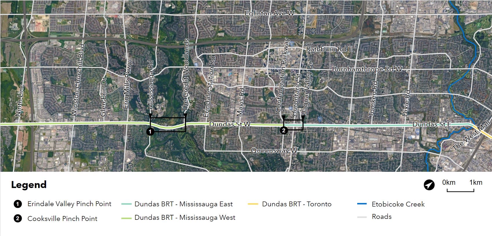
Environmental Considerations

  • Natural features (trees, vegetation, watercourses)
  • Known cultural/built heritage resources
  • Land uses
  • Community character

Geometrics / Infrastructure Considerations

  • Minor vertical and horizontal alignment adjustments
  • Multi-modal cross-section (transit lanes, general purpose lanes and active transportation facilities)
  • Continuity of infrastructure (transit lanes, active transportation facilities and utilities)
  • Capital cost, including technical challenges and complexity and ability to stage construction with managed impacts to traffic and the community*

Mobility and Traffic Considerations

  • BRT travel times
  • Auto travel times/operations
  • Queue lengths
  • Level of service
  • Transit Service Reliability*
  • Cyclist accessibility and connectivity*
  • Pedestrian accessibility and connectivity*
  • Road safety*

Property Considerations

  • Land acquisition and building displacement
  • Approved development applications
  • Municipal development planning and policy