
Davenport Diamond Greenway LIVE - November 24, 2022
- Projets et Programmes
- Prolongement de la ligne GO de Barrie
- Événements
- Davenport Diamond Greenway LIVE - November 24, 2022
Davenport Diamond Greenway LIVE - November 24, 2022
On Nov 24, the project team presented an update on the Davenport Diamond Greenway project and answered questions about the project. The panel included experts from the project team.
Metrolinx provided a brief presentation followed by a question-and-answer session.
Agenda
- 7:00PM - 7:30PM: Project Update
- 7:30PM - 8:00PM: Questions and Answers to Pre-Submitted Questions
- 8:00PM - 8:30PM: Call-in Questions
Event Recording
Panel
William Norman
Community Engagement and Issues Specialist, Toronto West (Moderator)
Kim Storey
Architect/Principal, Urban Design and Architecture Lead, Brown and Storey Architects Inc.
Lisa Mactaggart
Landscape Architect, Landscape Architecture Lead, Brown and Storey Architects Inc.
Josh Fullan
Director, Community Engagement Lead, Maximum City
Questions and Answers
Connection to Earlscourt Park
Connecting this active transit corridor safely north to Earlscourt Park would create enormous value for this community by giving us - and the many thousands of new residents coming with intensive development - access to one of the larger green spaces in the area. Ideally this would take the form of a pedestrian bridge across Davenport Rd to Earlscourt.
Previously, the Metrolinx team has mentioned that this crossing was ruled out due to the proximity of the overhead hydro corridor that runs east-west south of davenport. But this argument does not make sense considering that rail traffic with overhead wires will also run under the hydro corridor, in closer vertical proximity. Surely some infrastructure protecting vulnerable road users can be accommodated to complete this link and render it truly enabling by connecting people to green spaces?
Answer:
The proximity to hydro lines is an issue and it would impact where any future connection could be launched from. There are designs at the northern terminus of the multiuse trail connection to connect to Davenport and there is both the ramp and the stair structure. Those connections are designed to allow for future direct connections to Earlscourt Park. Based on the Environmental Assessment (EA) for the Bloor-Lansdowne GO Station, we have a a 10-year window in which the City, Metrolinx or another interested party could consider a bridge connection to Earlscourt Park. The City of Toronto is making plans for the Green Line linear park system planned to run along the hydro corridor, and the design of the multiuse trail is anticipating being designed to connect into this.
Removing Fences along the Greenway
Once the project has been completed, will all fences along the elevated guideway be removed? The project will most benefit residents if there’s free flow between east and west sides of the rail allowance.
Answer:
When the Greenway is complete, and the multi-use trail (MUT) opens, Metrolinx will remove fencing on our property, except where required for safety purposes. At this point, any adjacent landowner/business can create their own connections to the MUT be it through their property. Once the multi-use trail is open, the City of Toronto considers those facades not as back rear facades but front facades, so they will become under the City’s own zoning bylaws, primary frontages. At that time property owners will be free to accommodate businesses that are accessed and serve people using the multi-use trail. We expect the opening of the Greenway will spark changes in use like what you can see along the West Toronto Railpath. The Greenway is meant to act as a catalyst to change in this neighbourhood through the provision of new amenities, east-west connections, and new uses for buildings.
Can you please highlight the changes from the original plan?
Can you highlight the changes made from the original design plan? I understand that the artwork that was supposed to enliven the wall is now gone.
What will be done to prevent the graffiti, which is already present on the wall even through it is not even done yet?
Answer:
Graffiti Management is continuous activity built upon a number of strategies.
- Deterrence Strategies
- Apply graffiti resistant coatings or protectants on vulnerable surfaces
- Pigmented coatings that can be over-painted.
- Clear anti-graffiti coatings with silicone-based "slip additives" (this stops paint from adhering to surfaces).
- Landscaping and vegetation adjacent to vulnerable surfaces
- Vines, plants, and shrubs (natural or artificial) are a proven graffiti deterrence strategy as long it does not impact the ability to inspect retaining walls.
- Restrict access to walls or vulnerable areas
- Graffiti writers will not waste their time or materials and are unlikely to return to locations that are difficult to access.
- Increase lighting
- Increasing lighting in vulnerable areas to discourage vandals
- Murals
- Murals have a successful track record in reducing graffiti vandalism and replacing it with vibrant, colourful, community-engaged street art
- Timely removal of graffiti
- Timely removal is an ongoing challenge for municipalities and transit agencies
- Timely graffiti removal or over-painting helps reduce the spread and re-occurrence of graffiti
In terms of overall project design, there have been changes as there always are on major projects involving landscaping and architecture such as these as it evolves from concept to detailed design and tendering for construction. The basic framework of this project was set back in 2015, and the Residents Reference panel process led by Mass LBP which took place over several months and involved canvassing hundreds of volunteers to work with us in visioning exercises. Out of this process came a number of concepts and recommendations that underpin the Guideway design you see today. The Residents Reference Panel material is still available for review. There have been changes in the details, but the big picture and foundational concepts for different areas along the Guideway have not changed.
In regards to the public art, a linear mural on the metal panels cladding the noise barriers was proposed as an art component to the project (these panels are visible on the Brown + Storey renderings). In 2018 there were a series of decisions made at the senior level of government that resulted in some changes to Metrolinx’s mandate and directives. As part of that process the public art program was removed from Metrolinx’s mandate and, as a result, this mural project was cancelled. To compensate for this we did restore the enhanced Guideway cladding panels similar to what was proposed in 2016. The noise barriers on the elevated guideway are currently being installed. Once that is complete the reflective cladding panels will start being installed.
Can you explain the removal of public art from the noise wall?
The community was promised a lively artwork on the noise/construction long wall that was built. My understanding is that this has been no cancelled. A lot of us were not in favour of this, two-three stories high in some places, however, we accepted it with the understanding that it will be made visually appealing. Now, this artwork has bene cancelled. We would like to know why it was cancelled, what is the $$ impact and where the money went instead. It is not acceptable to add more drab to the community.
Answer:
There was a public art program that proposed a linear mural on the metal panels along the noise barriers on the elevated guideway. The removal of the public art program from the Metrolinx mandate and directives extended to this project. With the removal of the public art a decision was made to restore enhanced guideway cladding to the project. This cladding specification was in line with the original concepts for the bridge elements presented to the public with adaptations in response to comments from the community. The Greenway will add significant amenities, landscape, planting, and outdoor multi-purpose spaces along much of its length.
Public Art
Will there be spaces for public art, pop-up’s, small outdoor events along the Greenway?
Answer:
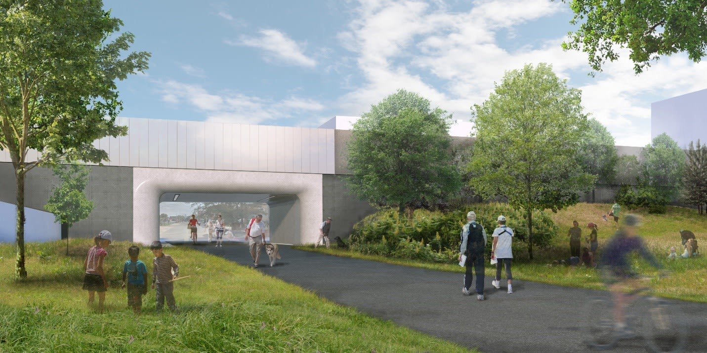
Wallace Square (just north of Wallace Avenue) is meant to be an outdoor multi-purpose space specifically designed to accommodate various outdoor activities including markets, public art, pop-ups, and other events. There will be mechanical and electrical infrastructure in place for Wallace Square to support these types of events, but there are other opportunities all along the Greenway for outdoor events, such as crossings as Dupont. The Greenway was designed as a framework for the community to occupy and make its own over time, and we anticipate the ways the community will want to use the space will change and evolve over time, similar to how the West Toronto Railpath has been a catalyst for change in neighbourhoods.
How will unfavourable loitering be discouraged, so that it is a positive space in the community?
Answer:
These are open public spaces, and people have a right to be there – but if the question is regarding how we can enhance the feeling of public safety and security of people using the Guideway, the design takes into account “CEPTED principals” around the design of safe and secure spaces. In addition, the lighting scheme is being designed to strike a balance between not overlighting the areas with the pollinator gardens and making sure there is a safe level of illumination along the multi-use trail and at the crossings.
The lighting will be brightest at the intersections, at places where people would like to sit. and along the MUT, so we have a constant level of illumination down the entire length. We want to highlight the connections where people can go on to another street and don’t feel trapped in a single line of travel. Highly visible connections are an important aspect of being safe and similar to what was done along the West Toronto Railpath. Being able to see around you is important - that’s why the design doesn’t have any thick hedges or other visual blockers that would prevent you from seeing clearly where you are going.
Cycling / Pedestrian Pathway
Will there be markings along the Greenway to indicate separate lanes for cyclists/pedestrians? The West Toronto Railpath is increasingly becoming more dangerous due to excessive speeds of cyclists and e-bikes. A separate lane, such as the Robert Goodman Trail, could be helpful.
Answer:
The current design of Multi-Use Trail (MUT) follows City’s Toronto Trail Design Guidelines for primary trails. The MUT path does not have sufficient width for an additional pedestrian-only area. We have a narrow path being the MSE Wall and the adjacent property line. The Greenway between Wallace and Dupont does have a secondary pathway separate from the MUT with the landscaping so some areas do have a wider area but not the entire stretch.
When will the Paton Road pedestrian underpass open?
Is this connection still on track to open in spring 2023 before the rest of the greenway opens? Will access to the underpass be maintained during greenway construction?
Answer:
The plan is to finish the Guideway portion and then handover to the public realm construction, so it could be a time that it may be open for the public but until the time that the Greenway public realm contractor is in place, the contractor will use that location as construction access because there is no other access from Paton to the south to Bloor, and also nothing in between Wallace and Paton, so that will be the major construction access for the contractor. 640 Lansdowne, the current construction laydown area will be used by the next contractor so we are work on the plan and whenever is possible in terms of when it is safe for the public to allow pedestrians to come through, but there will be construction fences until that time, this is the current plan.
Is project running late with opening (spring 2023)?
Answer:
If this refers to the Guideway project which is under construction now, the original schedule we had has faced challenges in the past two-three years because of the pandemic which caused some labour and supply shortages, as well as a strike event happening. The Guideway project has overcome some of these challenges so the current status of the timeline is still on time with a 90 day delay, with a target substantial completion day in late summer 2023. The Greenway aspect of the project will start work once the tenders have been awarded.
Gantry crane footings
At Wallace, there are concrete footings on either side of the guideway used for the gantry cranes. These are approximately 1 m high by 1 m wide and about 20 m long. Will these be left in place and incorporated into the greenway or demolished?
Answer:
The footings are also along the Guideway girders at the grade level, when all the concrete girders have been launched, we won’t need the footings after this and they will be removed by the contractor once we have trains on the Guideway.
Access across railway
Will there be access between east and west sides of the railway (under it, I presume) between Davenport and Dupont?
Answer:
Between Dupont and the CP line, there is a tall condominium crash wall on the east side of the Metrolinx property, and on the west side is commercial buildings, so there is no connection/public road. North of Dupont is the continuous solid MSE wall up to south of Davenport, so there are no physical connections between east and west of Metrolinx’s land in this area.
Why does the west sidewalk connection slope down at Dupont?
Could the sidewalk be raised to the ground level of the library building on the west side of the greenway so pedestrians wouldn't have to go down then up?
Answer:
To level out the sidewalk, we would need to expand the ramp further west, and there are a lot of utilities at the intersection, as well as hydro infrastructure in that place, so building further would require building more footing to support the ramp which would interfere with the existing utilities.
Where is the off leash area going to be?
Answer:
The dog off leash area (DOLA) is still under negotiation between Metrolinx and the City of Toronto, everyone is working on a solution to this, we will share updates as they develop at future public meetings.
The proposed location is by the outdoor ice rink, by the south side of Campbell Park. The details and the crafting of the agreement between Metrolinx and the City for maintenance and operations are still ongoing, we want to work with the local Councillor to get this done.
Krickhahn Park gap
The ramp along Krickhahn Park North of Bloor has a one meter gap between the park and the train ramp. This seems like it could collect garbage and become potentially dangerous. Is there any plan to mitigate for this?
Answer:
For this area, we have spoken to our contractors, and they are planning to fill this gap with soil as there is the retaining wall adjacent.
How will the path cross Wallace?
Will there be any signals installed? What are the planned pavement markings or surface treatments?
Answer:
There are no signals as per City of Toronto requirements.
At each location there is a full assembly of elements that indicate to the cyclist and pedestrian that there is an approaching intersection. The design for markings on the MUT at the intersection with Wallace Avenue are as follows in order from south to north:
- Asphalt MUT
- “ROAD AHEAD” painted white on asphalt MUT, 17 meters (55’ +/-) ahead of actual road crossing.
- Green painted patch 6.2 meters long with “SLOW” painted in white
- Tactile warning strip
- Concrete surface 6.5m from crossing
- 2nd tactile warning strip with curb cut
- Wallace Avenue crossing with crossride markings as per City of Toronto MUT guidelines
- North side of Wallace Avenue has the same elements as noted above
- North side of Wallace Avenue also has Signage Beacon marking ‘WALLACE’.
What are the accessibility features offered on this project?
Will you provide accessibility accommodation for various needs? Signage in braille? Contrasting and texturized ground colours? Smooth pathways for walkers and mobility devices? Any walkway on an incline or decline? Benches for customers who may be able to walk for only a short distance at a time. What type of accessibility expert or consultations have you gone through?
Answer:
The design team has worked with Metrolinx to ensure that the Greenway is fully accessible. Along the length of the Greenway between Wallace and Dupont there are ten seating areas set into the pollinator gardens called ‘rafts’. These are seamlessly connected to the MUT and have different pavements like bricks, granite, wood, and concrete that are all detailed to be fully accessible to the asphalt MUT. The MUT area between Bloor Street and Wallace Avenue is a narrower space but will also have benches provided along its length. All inclined areas are less than 5% slopes, including the Dupont sidewalks that connect the city sidewalk up to the Greenway at Dupont Street, the three level ramp that connects the Greenway to the pedestrian bridge over the CP railway, and the ramp at Davenport Road that connects the MUT to the city sidewalk at Davenport Road. Signage design is under development now and will have braille figures and are being designed using the Metrolinx Universal Access code sign guidelines as well as the AODA as guides to make sure that all accessibility needs have been addressed. This work is being done by the design team.
Crossing south of Bloor
Though technically out of scope for this project, the connection south of Bloor is critical in enabling a connected and protected cycling and pedestrian route for this community. It would also give us access to the Bloor-Lansdowne GO / SmartTrack station. What barriers are there to construction? Is this still in the plans? Will a pedestrian / cycling bridge over Bloor be constructed (it is in some of the renderings but not all of them)? There is real worry that these critical amenities will be "de-scoped", so we'd like assurances, and an indication that the budget is set aside for this next phase.
The connection south would eventually link up with the West Toronto Railpath where it hops the Barrie line to run south along the east side of the tracks all the way to downtown (Phase 2, 2025).
Answer:
The SmartTrack Bloor-Lansdowne GO station scope of work includes a multi-use path that connects to the Davenport Diamond Greenway, via a bridge over Bloor St W. The multi-use path will run along the east platform of the station. The SmartTrack King-Liberty GO Station project scope will continue the multi-use path from Dora Ave to Dundas St W, with a future connection to the West Toronto Rail Path Extension.
Barrie line electrification
Is Barrie line getting electrified first?
Answer:
Final dates and schedule will be determined through the GO Expansion – OnCorridor Works project’s development phase (2022-2024) and the successful proponent’s schedule.
Dora Ave Pedestrian Tunnel and Bridges
What are the timelines for the completion of the pedestrian tunnel connecting Dora Ave and Sterling Rd, and, the pedestrian bridges further north?
Answer:
The SmartTrack Bloor-Lansdowne GO station scope of work include a multi-use path via bridge over Bloor St W, a tunnel at the north end of the station, and access points to the station at both Dora Ave and Sterling Rd. The project is currently in procurement. At a high-level, construction is targeted to begin in 2024 and be completed in 2027. These dates are subject to change. Timelines will become clearer once the project is awarded and the design phase begins.
Electrification
Will the Barrie line be electrified by the time the Greenway is complete?
Answer:
We anticipate that electrification of the Barrie Corridor will come after the Greenway is complete.
284 St Helens
What is the design plan for the Greenway where it runs adjacent to the west side of 284 St Helens?
Answer:
The elevated guideway returns to grade north of Bloor Street. There is not change to the elevation of the rail corridor south of Bloor.
Will the Wiltshire/Exeter Hydro stations be moved/burried?
Answer:
The Metrolinx Greenway project does not involve the Wiltshire/Exeter hydro station and will not move or bury the stations which are owned by third party and will not be affected by the Greenway project.
Work progress
A City's workers team has been taking measurement on Ennerdale Road to install very much needed speed bumps. Any news of their progress? Thank you and congratulations for your election
Answer:
This is related to city work and out of the scope of this project. For information on this city work, you can call 311 or email 311@toronto.ca
Will it ever be finished?
Answer:
The timeline is still on time with a 90 day delay, with a target substantial completion day in late summer 2023. The Greenway aspect of the project will start work once the tenders have been awarded.
Reconnaissance des terres
Metrolinx reconnaît que nous relions les communautés en construisant et en exploitant le transport en commun sur les terres traditionnelles des peuples Anishinaabe, Haudenosaunee et Wendat, pour qui ces terres continuent d'avoir une grande importance. Ces terres font l'objet de traités entre les Premières Nations et les gouvernements, et les promesses contenues dans ces traités demeurent pertinentes à ce jour. Metrolinx et ses employés s'engagent à comprendre l'histoire de ces terres et les impacts continus de la colonisation, et assument la responsabilité des actions visant à faire progresser la réconciliation. Metrolinx continuera à rechercher les connaissances, l'expertise et l'expérience de ses partenaires autochtones et s'engage à mener ses activités d’une manière qui repose sur la confiance, le respect et la collaboration.